
Residents across Perthshire and Angus are bracing themselves for a significant spell of wintry weather, as the national meteorological service has issued a series of warnings for snow and ice spanning three consecutive days this week. The adverse conditions are expected to affect higher elevations most severely, but crucial travel arteries, including the A9 and A90, could also experience considerable disruption, impacting commuters and local journeys.
The warnings highlight a period of sustained cold, with a potential for hazardous driving conditions and localized impacts on infrastructure. The local communities within Perth and Kinross are advised to stay informed and prepare for potential travel delays and reduced visibility. The unpredictable nature of snow and ice in these regions often necessitates careful planning, especially for those in more remote areas or reliant on specific routes. Detailed Outlook for Wintry Conditions
The detailed forecast from the Met Office outlines the specific timelines and geographical areas that will be under alert: Tuesday’s Initial Impact
The initial phase of wintry weather is predicted for Tuesday, commencing early in the morning and extending into the late afternoon. A yellow warning for snow will be active from 3 AM until 6 PM. This particular alert targets much of northern Perthshire, excluding the immediate Perth city area and the fertile Carse of Gowrie. Additionally, inland parts of Angus are included in this snow warning. During this period, areas situated above 150 meters could see snow accumulations ranging from 2 to 5 centimeters. This could mean challenging conditions for elevated rural roads and exposed stretches of major thoroughfares traversing higher ground within these zones.
Concurrently, a separate yellow warning specifically for ice will be in effect from 5 AM until noon on Tuesday. This warning covers a broader central belt of the region, encompassing Perth itself, Kinross, and Stirling, alongside the western fringes of central Fife. Motorists in these areas should anticipate icy patches, particularly on untreated surfaces, secondary roads, and shaded areas where moisture might freeze. This early morning ice risk adds another layer of complexity to the commute, advising extra caution and potentially slower travel times. Extended Alert for Mid-Week
The challenging weather pattern is set to continue and intensify through the middle of the week, with an extended yellow weather alert for both snow and ice. This comprehensive warning begins at 6 PM on Tuesday and stretches until 9 PM on Thursday. The primary focus of this longer-duration alert is Highland Perthshire and the northern reaches of Angus. These mountainous areas are particularly susceptible to significant snowfall and prolonged icy conditions, which can lead to more severe travel disruptions and isolated communities.
The Met Office indicates that while snow amounts will exhibit considerable regional variation, frequent showers could deposit 2 to 5 centimeters of snow at lower altitudes. For hills rising above approximately 100 meters, accumulations of 5 to 10 centimeters are possible. In the highest elevations, specifically above 300 meters, there is a potential for substantial snowfall, with forecasts suggesting as much as 15 to 20 centimeters. This level of snow can have a profound impact on local services, access, and daily routines in communities like Pitlochry, Blairgowrie, and the Angus Glens. Additional Hazards and Preparations
Beyond the direct snowfall and ice, the Met Office has highlighted further potential hazards accompanying these wintry conditions. Gusty winds are expected to accompany some of the showers, which could lead to drifting snow, particularly over exposed moorland routes, and reduce visibility to near zero in whiteout conditions. These strong winds can also exacerbate the feeling of cold and increase the risk of hypothermia for anyone caught unprepared outdoors. There is also a possibility of isolated lightning strikes, which, although less common in winter, can pose additional risks during intense shower activity.
Furthermore, the fluctuating temperatures typical of this time of year mean that snow which falls and partially thaws during the day could refreeze overnight, creating widespread icy surfaces. This freeze-thaw cycle is particularly dangerous as black ice can form, making roads and pavements extremely slippery and difficult to detect. Local authorities and emergency services in Perth and Kinross are likely to be on heightened alert, coordinating resources for gritting operations and responding to incidents.
Residents are strongly encouraged to undertake necessary preparations. This includes ensuring vehicles are winter-ready with adequate anti-freeze, good tires, and emergency supplies. Planning ahead for travel, checking local road conditions before departure, and considering alternative travel arrangements will be essential. Keeping abreast of the latest weather updates and official guidance will be paramount for safety and minimizing disruption throughout this extended period of challenging winter weather across Perthshire and Angus.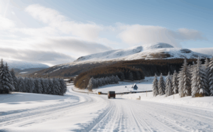